.png)


Moors the Merrier
Type:Walking Event
Fox Lane
Holmesfield
Dronfield
Derbyshire
S18 7WG
Call direct on:
Tel01246 345777

About
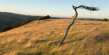
Moors the Merrier is a circular walk, essentially over open moorland, taking in a defunct reservoir now left to rewilding. The return is via a broad trail through open scrub and woodland.
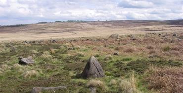
Commencing at Shilito Woods our route first uses a country lane to pass alongside leash fen, part of the important eastern moors. Leaving the road, we travel along the southern edge of Ramsley Reservoir before turning northwest to enter and cross big moor with the chance to see one of the stone circles which dot this moor. Skirting the remains of Barbrook Reservoir, we cross to Barbrook Bridge and then turn west to reach the end of white edge.
A sharp turn north leads towards longshaw but before reaching the lodge we turn east to cross totley moss, yet another of our wonderful moors, towards brown edge.Here we start the return journey to pass between salter sitch and flask edge to reach salter sitch bridge. We then recross a coner of big moor before decending slowly through the lovely and basically wild area of greaves piece. On to car lane then a gentle climb along a broad track through sparse woodland to return to the car park.
Booking essential
Find us on whatthreewords - ///survivor.breaches.lunging
Grid reference – SK 2953, 7496
This is a circular walk
1-5 stiles
Bring a packed lunch
Organised by Chesterfield Ramblers
Guide Prices
Booking essential. Admission free. Donations will for the Mountain Rescue and Air Ambulance will be gratefully received.
Facilities
Children
- Children welcome - Children under 16 must be accompanied by an adult
Parking
- Free Parking
Property Facilities
- Dogs Accepted - Dogs must be on a lead
Routes
- Accessibility of route - Leisurely
- Description of route - Circular walk, 3 rest stops, 1-5 stiles Bring a packed lunch
- Length of route (miles) - 10 miles
- Typical duration of route - 5½ hours
Opening Times
Sorry, this event has passed
Map & Directions
Road Directions
From North/South Leave M1 motorway at Junction 29 and take A617 to Chesterfield (approx 4 miles). At traffic light controlled roundabout select right lane and take 4th exit (A61 signposted Sheffield). At next traffic light controlled roundabout (Tesco) take 2nd exit (A61) and, at next roundabout (Domino’s) select left lane and take 2nd exit (B6050). Follow road for approx 2¼ miles to staggered cross roads (Four Lanes End). Turn right (B6051 signposted Barlow). Follow road into Barlow Village and continue following same road to Millthorpe (Royal Oak on right). Continue on B6051. Where B6051 forks right, go straight on into Fox Lane. Follow Fox Lane for approx 1.5 miles and Shillito Woods car park is on right.
From East Take A617 to M1 motorway junction, then follow route from North/South.
From West Follow A619 or A623 to Baslow, continue through Baslow, passing Wheatsheaf on left to roundabout and take 1st exit (A621, signposted Sheffield). Follow road for just under 2 miles and turn right onto Fox Lane. Follow road for just over 1 mile and Shillito Woods car park is on right.
Public Transport Directions
Nearest train station Chesterfield, approximately 7.5 miles away
Not accessible by bus.

